Research
Teaching Machines to Read Zoning Codes
The NZA is participating in a legal technology project to identify natural language processing techniques for automating information extraction from textual zoning codes. The first phase, involving a collaboration with the Urban Institute to test a processing tool on Connecticut zoning codes, yielded the publication "Automating Zoning Data Collection: Results from a Pilot Effort to Automate National Zoning Atlas Methodologies." The project is now in its second phase, partnering with Professor Alexander Rush at Cornell Tech to extract structured data from a broader sample of codes from the National Zoning Atlas. The project, funded by the National Science Foundation and Texas A&M AgriLife Extension Program, aims to create a robust data infrastructure to help researchers better understand zoning's impact on housing, transportation, the environment, the economy, education, and food supply.

Principal Investigator Prof. Sara Bronin and Co-Principal Investigator Prof. Sasha Rush present on “Automating Analysis of Zoning Codes for the National Zoning Atlas” at the Cornell Tech’s Urban Tech Conference in May 2023.
Investigating the Intersection of Zoning, housing, & flood Risks
The Cornell Legal Constructs Lab in collaboration with the Regional Plan Association is leveraging the New York Zoning Atlas to research likely future housing needs in the face of rising seas and increased flooding, New York State's ability to meet those needs, and policy interventions necessary to ensure enough housing can be built to allow for a managed transition out of the highest-risk areas. Researchers will use the zoning data to develop a common tool with a single measure—units of housing lost to climate impacts—to advance housing solutions and climate plans at a local level. In addition, this research intends to inform similar efforts conducted by other regions through development of a replicable methodology for determining how much additional zoning capacity is needed to address future housing loss due to climate impacts
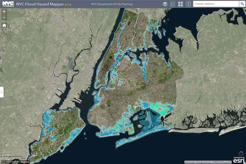
NYC Flood Hazard Map, courtesy of NYC Department of City Planning.
Using Parcel-Level Data to Inform Regional Land development
The Center for Regional Change at the University of California, Davis, is part of the team building the California Zoning Atlas to help researchers and practitioners understand zoning patterns across the state. The team is analyzing parcel-level data to show how single-family, multi-family, and mixed-use zones vary between incorporated and unincorporated areas. Preliminary findings demonstrate the need for and power of using standardized zoning maps and replicable methods. To inform local and regional conservation and land development policy, the team is currently analyzing planned agricultural, conservation, and development patterns across California and will release a publication of findings in the coming months.
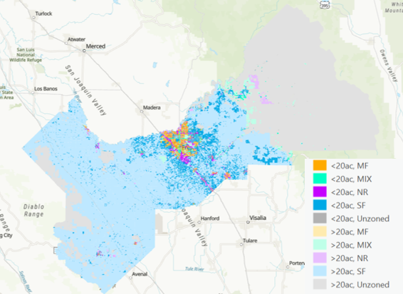
Fresno, CA parcel analysis, courtesy for the Center for Regional Change.